


Doucy le torrent du Morel

ARPF
User
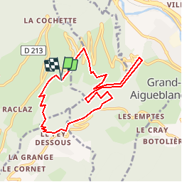

Length
8.7 km

Max alt
950 m

Uphill gradient
636 m
Km-Effort
17.2 km

Min alt
488 m

Downhill gradient
638 m
Boucle
Yes
Creation date :
2019-01-15 12:58:13.98
Updated on :
2019-01-15 12:58:13.98
3h25
Difficulty : Easy

FREE GPS app for hiking
 SityTrail
IGN / Geographical institutes
SityTrail Plus
The world is yours!
About
Trail Walking of 8.7 km to be discovered at Auvergne-Rhône-Alpes, Savoy, La Léchère. This trail is proposed by ARPF.
Positioning
Country:
France
Region :
Auvergne-Rhône-Alpes
Department/Province :
Savoy
Municipality :
La Léchère
Location:
Unknown
Start:(Dec)
Start:(UTM)
302511 ; 5041654 (32T) N.
Comments